Seismic and Vibration Monitoring Stations

Precision sensing for structural safety and dynamic environmental risk assessment

Overview

Seismic and vibration monitoring stations are critical for identifying, measuring, and analyzing ground and structural movement caused by natural or man-made forces. From detecting microtremors in seismic zones to monitoring construction-related vibrations near sensitive infrastructure, these systems offer crucial real-time data for structural engineers, city planners, disaster response teams, and industrial operators.

By capturing parameters like ground acceleration, velocity, displacement, and frequency spectra, these systems provide actionable insights to mitigate risk, assess damage, and ensure long-term resilience. Their application extends across geotechnical engineering, infrastructure health monitoring, and regulatory compliance efforts in both urban and remote settings.

Enviro Structural Monitoring supports clients across North America with customizable, high-performance seismic and vibration solutions. We help B2B clients navigate seismic risks and industrial impacts through quality-driven technology, comprehensive system integration, and expert support—backed by our reputation for reliability, innovation, and customer-centric service.

Instruments and Systems You Can Trust

In addition to offering products and systems developed by our team and trusted partners for Seismic and Vibration Monitoring Stations, we are proud to carry top-tier technologies from Global Advanced Operations Tek Inc. (GAO Tek Inc.) and Global Advanced Operations RFID Inc. (GAO RFID Inc.). These reliable, high-quality products and systems enhance our ability to deliver comprehensive technologies, integrations, and services you can trust. Where relevant, we have provided direct links to select products and systems from GAO Tek Inc. and GAO RFID Inc.

Core Components

Hardware

Several soil sensors, including a digital chip and analog gauges, are placed in rich, dark soil in a field with plants in the background, capturing environmental data.

Broadband and Short-Period Seismometers

High-sensitivity sensors for accurate seismic detection across multiple frequency ranges

Groundwater Level Sensors

Triaxial Accelerometers

Capture three-dimensional ground motion with precision

A collection of electronic devices including a gateway with antennas and multiple ports, surrounded by smaller rectangular devices with LED indicators and a digital display showing "LOGGING DATA." The setup is arranged neatly on a smooth gray surface.

Geophones and Geotechnical Vibration Probes

Monitor surface and subsurface motion

A collection of compact, rectangular electronic devices with digital displays are arranged on a metallic surface. Each device shows readings like temperature, humidity, and battery percentage, with colorful cables connected to them.

Data Acquisition Units (DAQs)

Robust, low-noise logging hardware with real-time signal processing

A collection of various electronic devices, including black and silver enclosures with transparent panels, are displayed on a table. Several power adapters are connected with colorful wires, and circuit boards with components are visible, creating a complex and organized technical setup.

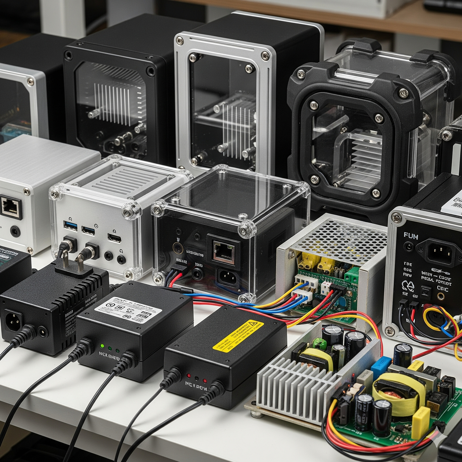
GNSS Synchronization Modules

Time-synchronized data capture across networks

A group of metal electrical boxes with small solar panels on top are installed in a desert landscape under a blue sky with scattered clouds.

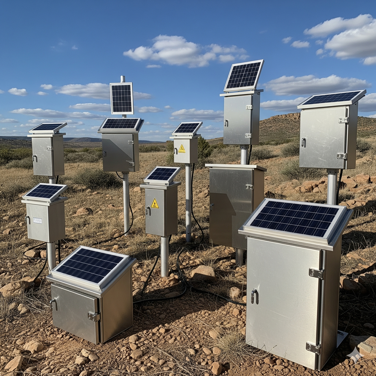
Solar-Powered and Weather-Resistant Enclosures

Ruggedized field-ready deployment options

Software

Data Visualization Dashboards

Seismic Analysis Platforms

Evaluate waveform data, spectral densities, and frequency response

A security officer monitors multiple surveillance screens in a control room, pointing at a digital map on a computer displaying alert locations. The room is equipped with a prominent red "PANIC" button and a wall-mounted siren, creating a high-tech, vigilant atmosphere.

Event Detection & Notification Systems

Real-time triggers for earthquakes, blasts, and anomalies

A technician in a lab setting is calibrating sensors using various electronic equipment, including oscilloscopes and multimeters. A large screen displays a "Sensor Calibration & Management Tools" interface with graphs and data. The workspace is organized, with cables and devices neatly arranged on the table.

Historical Trend & Risk Profiling Tools

Analyze site activity patterns for long-term mitigation

Cloud Services

A glowing digital sphere connects to various technology icons above server racks, representing a data network or cloud computing system in a cityscape setting.

Remote Monitoring Dashboards

Real-time data visualization, historical playback, and mobile access

A futuristic device emits a stream of glowing digital particles, connecting to a timeline marked with years like 1960, 1990, and 2000, set against a dark, grid-patterned background.

Automated Reporting Systems

Generate compliance-grade reports for regulators or stakeholders

API Integration

API & Integration Frameworks

Easily connect with SCADA, BMS, and third-party analysis tools

Key Features and Functionalities

Key features checklist

Ultra-sensitive seismic and vibration sensing with configurable thresholds

Key features checklist

Multi-sensor synchronization for large-scale and distributed deployments

Key features checklist

Wireless transmission options (LTE, LoRaWAN, Wi-Fi, satellite uplink)

Key features checklist

AI-assisted event detection with false-positive suppression

Key features checklist

Scalable design for permanent, semi-permanent, or temporary installations

Key features checklist

Real-time alerts via SMS, email, and integration platforms

Key features checklist

Auto-redundancy and failover for uninterrupted critical monitoring

Integrations and Compatibility

SCADA and Industrial Automation Systems

Smart Building and Infrastructure Health Monitoring Platforms

Emergency Response Networks and Disaster Early Warning Systems

Geotechnical and Structural Engineering Analysis Suites

Smart Cities and Urban Planning Platforms

Benefits

Minimize damage and risk through real-time structural movement detection

Ensure regulatory compliance with vibration limits during construction or blasting

Improve disaster preparedness and response in seismic-prone regions

Reduce liability and protect critical infrastructure

Enable remote or autonomous monitoring in hard-to-reach locations

Correlate seismic data with structural health monitoring for holistic insight

Save costs through preventive alerts and trend analysis

Applications

Applications

Monitoring critical infrastructure such as bridges, tunnels, and dams

Applications

Seismic activity detection in fault-prone geographic zones

Applications

Construction and demolition site compliance

Applications

Oil & gas drilling operations and fracking sites

Applications

Mining and quarry vibration monitoring

Applications

Urban rail, metro, and subway systems

Applications

Nuclear and energy facility safety management

Industries We Serve

A cityscape featuring a cluster of modern skyscrapers under construction, with multiple tall cranes surrounding them. The scene is set against a sepia-toned sky, giving it a vintage look. Elevated highways crisscross in the foreground, adding an urban complexity to the composition.

Civil Infrastructure & Engineering

A lush forest scene with tall, slender trees reaching upward, surrounded by dense green foliage. A narrow, winding path cuts through the undergrowth, leading deeper into the tranquil woods.

Environmental & Geotechnical Consulting

An offshore oil rig stands prominently in the ocean, featuring a red and yellow structure with cranes and equipment. The clear blue sky and distant shoreline provide a serene backdrop.

Oil & Gas

A large open-pit mine with several excavators working on the rocky terrain, surrounded by steep, layered earth walls under a partly cloudy sky.

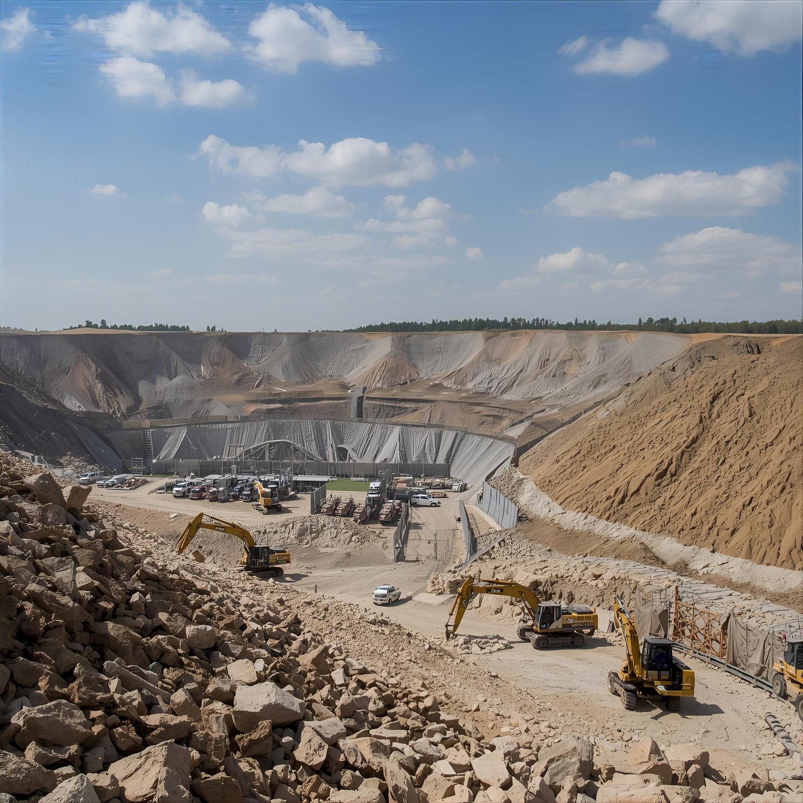
Mining & Natural Resources

A scenic landscape features tall power lines stretching across a grassy field at sunset, with a vibrant sky of blues and oranges creating a serene backdrop.

Transportation & Rail Systems

A city street at dusk features tall buildings lining both sides, with cars driving along the wet road reflecting the streetlights. The sky is overcast, creating a moody atmosphere in the urban setting.

Smart Cities & Infrastructure Planning

A bright yellow forklift is positioned in a spacious warehouse, maneuvering a large pallet. The industrial setting features high ceilings, metal beams, and stacks of boxes and materials, creating a busy and organized environment.

Government & Emergency Management

Relevant U.S. & Canadian Standards and Regulations

U.S. Geological Survey (USGS) Standards

ANSI S2.47 – Measurement of Vibration and Shock

ASTM D7338 – Monitoring Vibration of Structures

Canadian Standards Association (CSA S832) – Seismic Risk Reduction of Operational Equipment

Case Studies

Industrial complex under a blue sky with scattered clouds. Tall metal structures and pipes dominate the scene, surrounded by a chain-link fence.

U.S. West Coast Transportation Corridor

In a high-risk seismic zone in California, a transportation authority deployed a series of seismic monitoring stations along a major rail corridor. Using triaxial accelerometers and broadband seismometers, the system enabled early detection of microseismic activity, informing safety decisions and minimizing service disruptions. Data integration with SCADA platforms provided real-time alerts during earthquakes and allowed for predictive maintenance scheduling.

Historic red-brick building on a city corner at dusk, adorned with a construction crane. Warm lights emanate from windows, evoking a classic urban ambiance.

U.S. Midwestern Power Plant Vibration Control

A power generation company in the Midwest installed vibration monitoring stations around its steam turbine systems to detect excessive ground vibration and structural resonance. By incorporating automated alerting and compliance-grade reporting, the facility achieved higher uptime, better maintenance response, and full regulatory compliance for vibration thresholds during peak operations.

A striking aerial view of a large, deep blue reservoir surrounded by steep, layered canyon walls and dense green forests, under a partly cloudy sky.

Seismic Monitoring in Western Canada

A municipal agency in British Columbia required a scalable solution for earthquake preparedness in a suburban zone near a known fault line. Enviro Structural Monitoring implemented a network of solar-powered seismic monitoring units with wireless communication and cloud-based dashboards. The system delivered early warnings and supported real-time data exchange with regional emergency response services, improving resilience across multiple public buildings and transportation infrastructure nodes.

Ready to deploy seismic and vibration monitoring solutions tailored to your infrastructure or regulatory needs?

Contact Enviro Structural Monitoring today for expert consultation, customized system design, and end-to-end B2B support. We’re here to help you monitor what matters—accurately, reliably, and intelligently.

An illustartion representing environment
Scroll to Top